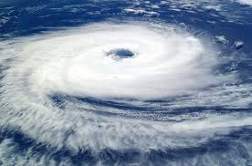
The Indian National Centre for Ocean Information Services (INCOIS) and the India Meteorological Department (IMD) on Monday issued a joint warning predicting high sea waves ranging from 2 to 4.7 metres along the Andhra Pradesh coast from Nellore to Srikakulam as Cyclone ‘Montha’ intensifies into a cyclonic storm.
According to the agencies, the high wave activity is expected to last for six hours — from 5:30 pm to 11:30 pm on October 27.
“High waves between 2 and 4.7 metres are forecast during 5:30 pm to 11:30 pm off the Andhra Pradesh coast from Nellore to Srikakulam,” the bulletin stated.
Cyclone Position and Movement
As of 5:30 pm on Monday, Cyclone ‘Montha’, which means a fragrant flower in Thai, was centered over the west-central and adjoining southwest Bay of Bengal, moving northwestward at 15 kmph over the past six hours.
The system was positioned about:
- 450 km south-southeast of Kakinada
- 420 km east of Chennai
- 500 km south-southeast of Visakhapatnam
- 670 km south-southwest of Gopalpur (Odisha)
The cyclone is expected to intensify into a severe cyclonic storm by Tuesday morning, according to the IMD.
Landfall and Impact Forecast
“Continuing to move north-northwestwards, the system is very likely to cross the Andhra Pradesh coast between Machilipatnam and Kalingapatnam, near Kakinada, during the evening or night of October 28 as a severe cyclonic storm with maximum sustained wind speeds of 90–100 kmph, gusting up to 110 kmph,” the Met Department said.
A storm surge of about one metre above the astronomical tide is expected to cause inundation in low-lying coastal areas of Andhra Pradesh and Yanam during landfall.
Rainfall Alert
Both INCOIS and the IMD have forecast light to moderate rainfall at most places in the cyclone-affected regions between October 27 and 29, with heavy to very heavy rainfall at several locations and extremely heavy rainfall (over 20 cm) in isolated areas.

